Predicting Climate
There are various ways climatologists present climate using different programs involving computers.
Satellite Imagery
The satellites we launch in space contain cameras, instruments and sensors. The equipment collects the data of the weather conditions around the globe such as the weather of different geographic regions and countries, ocean currents, wind directions, temperature, and precipitation and so on. The information is then sent to Earth, where the climatologists analyze and predict climate.
The satellite used to observe Earth from space, is called Earth-Observing Satellites. Canada currently operates three Earth-observing satellites, RADARSAT-1, RADARSAT-2 and SCISAT.
The satellite used to observe Earth from space, is called Earth-Observing Satellites. Canada currently operates three Earth-observing satellites, RADARSAT-1, RADARSAT-2 and SCISAT.
3 Types of Satellite Imagery:
Visible Imagery (VIS): Just like taking a photo with a normal camera, it requires sunlight to illuminate the object. This is why it can only be used in daylight because sunlight is needed for the image to expose.
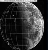
※ Example of Visible Imagery
Infrared Imagery (IR): The sensors in the satellites detect the heat radiated from the surface of the Earth. The warmer the object is, the darker the colour. On the other hand, the colder the temperature, the lighter the colour. Unlike visible imagery, infrared imagery can be obtained at any given point in time, with or without sunlight.
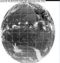
※ Example of Infrared Imagery
Water Vapour Imagery (WV): Shows the flow of water vapour through the atmosphere.
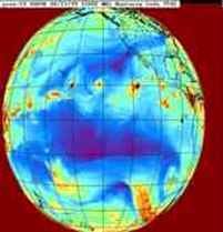
※ Example of Water Vapour Imagery